
Much of the PPJV’s science revolves around developing spatially explicit models of species-habitat relationships that highlight important areas to focus conservation. Through science investments in spatial planning tools, the PPJV can increase efficiency in how conservation dollars are targeted and measure how our work benefits bird populations.
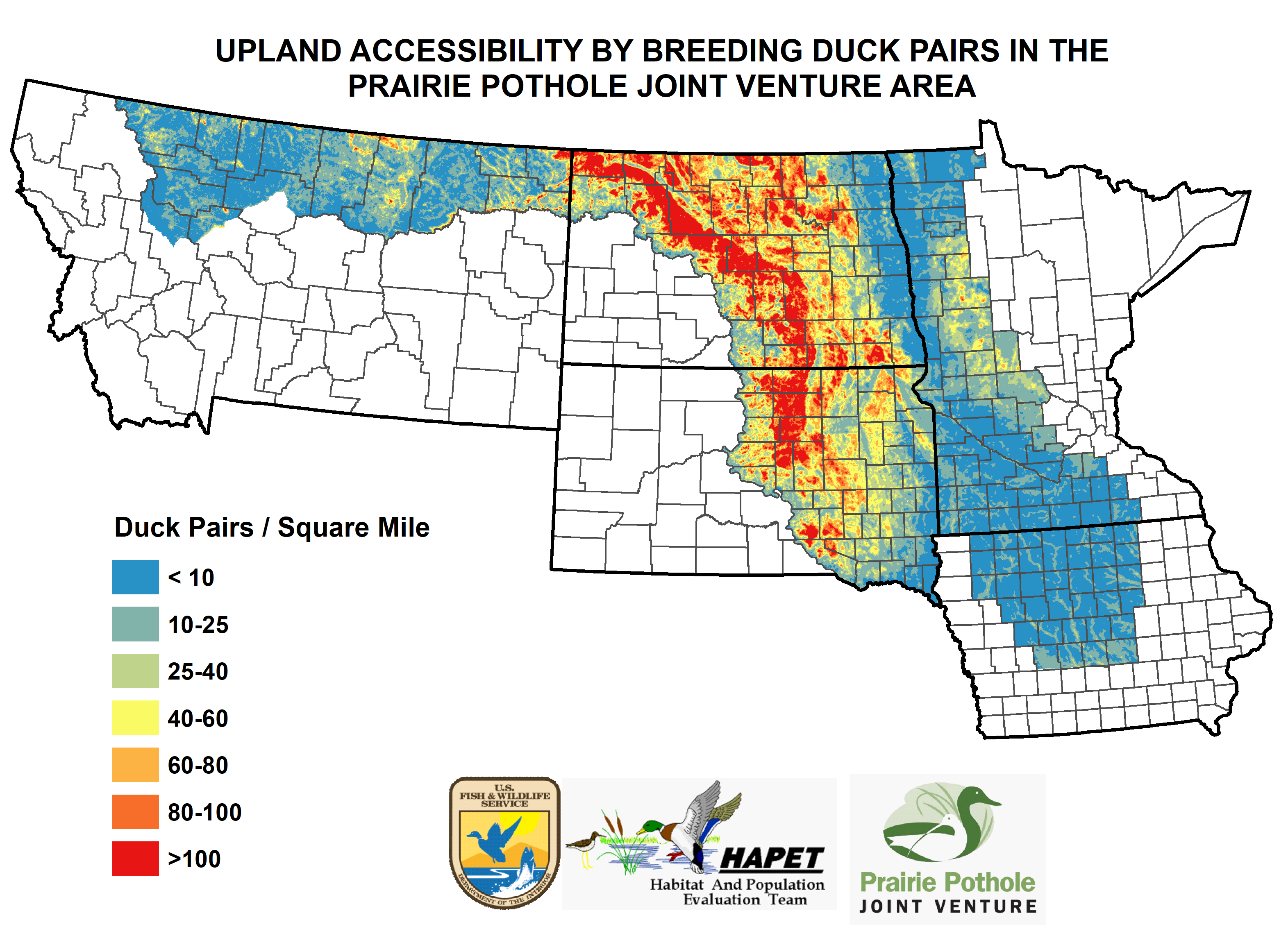
A prominent example is the “Thunderstorm Map” developed by the Habitat and Population Evaluation Team (HAPET) and the USGS Northern Prairie Wildlife Research Center (NPWRC). The Thunderstorm Map targets wetland and grassland habitat conservation that benefits breeding waterfowl in the PPR through programs like the Migratory Bird Conservation Fund. This innovative decision support tool is made possible with data collected from the annual Four-Square-Mile Breeding Waterfowl Survey conducted by HAPET, USFWS National Wildlife Refuges, and partners.
Similar tools for shorebirds, waterbirds, and grassland birds developed by HAPET science partnerships are used to inform conservation investments throughout the Northern Great Plains. For example, innovative grassland bird models that integrate Breeding Bird Survey data and landcover data are used to inform conservation that benefits a suite of priority grassland birds in the PPR.
These tools are used extensively by Joint Venture partners to prioritize the conservation and management of wetlands and grasslands. They are regularly updated to incorporate changes in landscape condition and bird populations, ensuring that conservation efforts are addressing the most pressing habitat needs of bird populations in the PPR.

Integrated Bird Conservation
As an “all bird” Joint Venture, the PPJV is committed to addressing the conservation needs of all avian species that use the region. Grassland and wetland habitat loss are generally recognized as the primary causes of declining bird populations in the PPR and serve as common denominators for conservation among waterfowl, shorebirds, waterbirds, and landbird populations. The Migratory Bird Conservation Fund and the Land and Water Conservation Fund both use a decision process that integrates priority areas for waterfowl, other grassland and wetland birds, and threatened and endangered species in their conservation easement and fee title acquisitions in the U.S. PPR.
Integrated bird conservation is also achieved by applying these tools to conservation programs that have objectives broader than wildlife habitat. The USDA’s Conservation Reserve Program (CRP) seeks to achieve multiple environmental objectives including reduced soil erosion, improved water and air quality, and wildlife benefits. Over the past several decades, the PPJV partnership has invested substantially in assessing the benefits of CRP and continues to work closely with USDA by providing new science and developing tools to target CRP placement for a suite of grassland birds – including waterfowl.