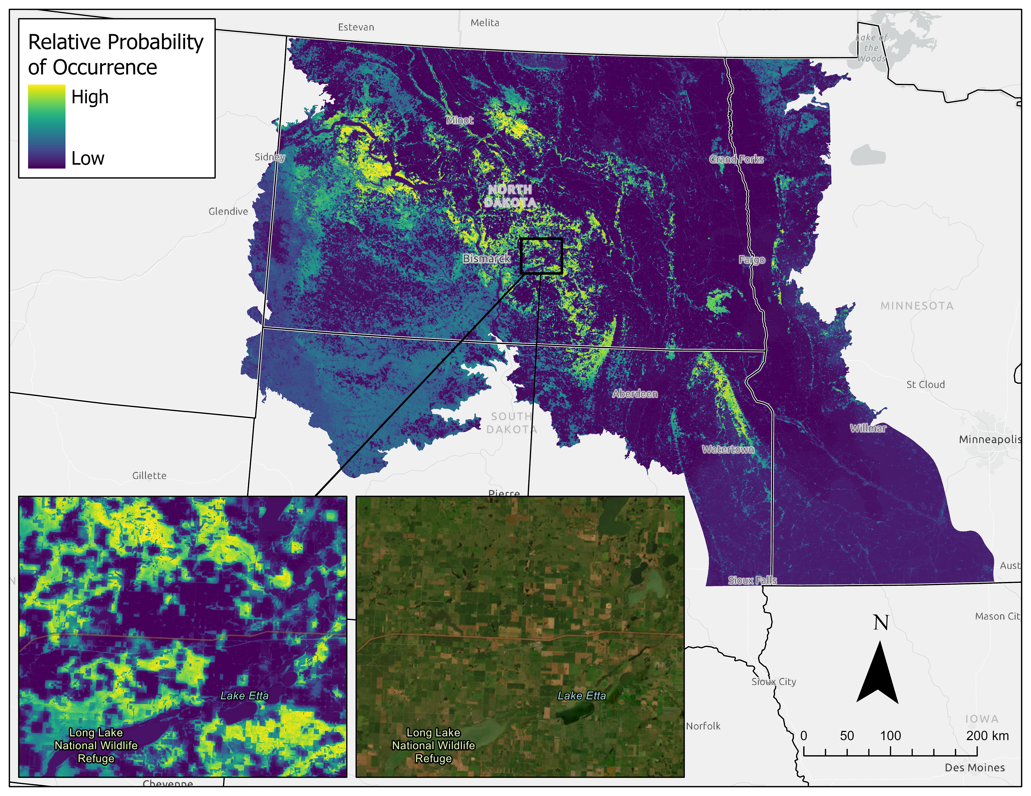
The Dakota skipper is a small, threatened butterfly endemic to the northern Great Plains that is emblematic of undisturbed native mixed-grass and tallgrass prairie. It was first proposed for listing in 1978 due to population declines and range contraction from habitat loss and degradation, and in 2014 was listed as threatened under the U.S. Endangered Species Act. To aid conservation planning and delivery for the Dakota skipper, biologists from USFWS Habitat and Population Evaluation Team and Ecological Services used a machine learning approach to develop a landscape-scale species distribution model that predicts relative probability of occurrence of Dakota skipper across portions of North Dakota, South Dakota, and Minnesota.

The model was developed by relating Dakota skipper occurrence data to a large suite of ecological predictor variables that represent land cover, vegetation biomass, disturbance history, surface reflectance, soil conditions, topography, and climate. Many predictor variables were summarized at both small and large scales to reflect a potential spatial hierarchy of settlement responses to environmental features. The number of predictor variables was reduced to the top 25 variables that best predicted Dakota skipper occurrence. The final model was spatially applied to the landscape variables to predict relative probability of occurrence (Figure 1). To our knowledge, this is the first Dakota skipper model to utilize a machine learning approach to investigate a large suite of high-resolution (i.e., 10-m) predictor variables, including multiple grassland characteristics (e.g., disturbance history, land cover, biomass, and reflectance) and landscape scales.
The final model contained several landcover and bioclimatic variables, one surface reflectance variable, two soil variables, and no topographic variables. The model indicated that Dakota skipper occurrence was positively associated with undisturbed grass containing high percent cover and biomass of perennial grasses and forbs, negatively associated with crop and restored grassland cover, and included quadratic associations with many bioclimatic and soil variables, indicating that specific abiotic conditions are associated with the species occurrence. The model supported a potential spatial hierarchy to settlement given the inclusion of variables summarized at multiple landscape-scales (e.g., 15-m and 800-m radius percent grass cover).
Several agencies are already utilizing the model for decision support. The Ecological Services program is using it to plan future surveys in locations of high probability of occurrence that have not been surveyed previously, and the Refuges program is using it to guide conservation delivery earmarked for pollinators. Western Area Power Administration is using the model for infrastructure planning in South Dakota. Leveraging the model and privately raised funds, The North Dakota Natural Resources Trust was awarded a grant from the National Fish and Wildlife Foundation to direct the delivery of $400,000 for the conservation of Dakota skipper habitat on private lands in western North Dakota. There is still research needed to better understand the specific ecological requirements for the Dakota skipper, the potential for re-establishment on restored grasslands, and the influence climate change may have on life functions. The continuation of successful collaborative conservation work such as this can help ensure the necessary research and conservation are achieved to maintain the Dakota skipper and other emblems of quality grassland on the landscape.