
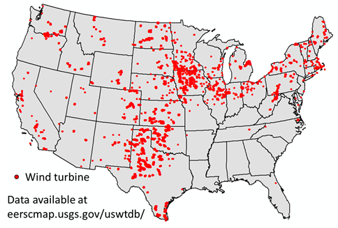
Wind farms are increasingly common across the landscape as society moves toward renewable sources of energy. As of October 2018, almost 27,000 turbines have been erected in the 48 contiguous US states, with the majority located in the Great Plains and upper Midwest. Many thousands of additional turbines are planned to be erected in coming years.
Effects of wind farms on wildlife populations are a growing concern, particularly the consequences of indirect effects such as displacement of birds around turbines, which may be especially problematic for species that evolved in open landscapes. Displacement of birds has been documented at numerous sites, but effects varied among species, locations, and times. In addition, studies have generally been restricted to one or few sites and a limited number of species over a short time frame, and in some cases study design has been less than optimal for making inferences about effects of turbines on birds. These limitations and disagreement about inferences that can be made from different studies complicate decision-making and conservation.
To overcome the limitations of previous studies, future research should ideally cover a broad geographic extent that includes many wind farms and control sites, have a large sample size with high statistical power, evaluate the response of many species, be rigorously designed and analyzed, and take place over multiple years. However, meeting these standards with traditional studies will be prohibitively expensive and challenging.
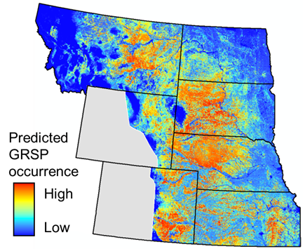
To help address these challenges, the Habitat and Population Evaluation Team (HAPET) is using data from the North American Breeding Bird Survey (BBS) to evaluate potential displacement of birds at wind farms. Bird-habitat models developed by HAPET using stop-level BBS data* are the foundation of this effort. These models predict bird occurrence or density across all or portions of seven states as a function of landscape composition and configuration, climate, weather, and topography, as well as factors influencing bird detection on surveys.
This project would add distance to the nearest wind turbine as an additional variable in the models. These models would provide additional insights into whether birds are displaced in proximity to turbines and, if so, the nature of the displacement. Turbine height, age, and configuration (i.e., multiple turbines around a stop) will also be evaluated through this approach.
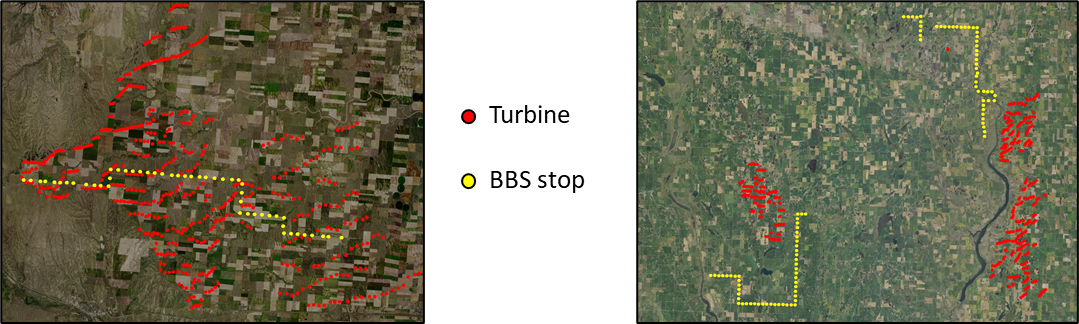
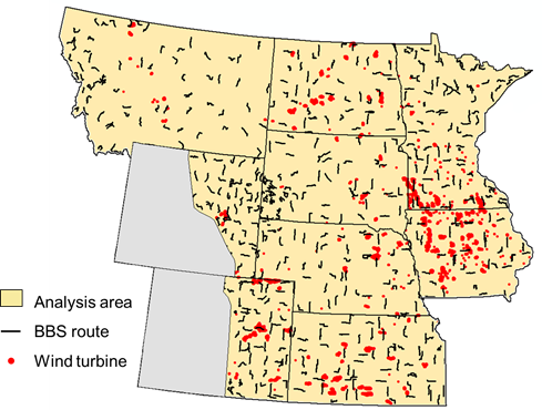
Using BBS observations across multiple states over several years will result in a large data set with high power to make inferences about birds. However, even though some BBS routes run through wind farms (below, left), most do not (below, right). Consequently, the ability to make inferences about the effects of wind turbines on birds would be limited.
To address this limitation, HAPET is working with partners to supplement BBS routes by creating additional “wind” routes that follow BBS protocol but are placed so that many of the stops are in proximity to wind turbines. BBS surveyors sample the new wind routes to create a balanced study design where the same people sample BBS routes with and without turbines. Additional balance will be created by ensuring that wind routes have stops with and without turbines close by.
The next generation of models developed with stop-level BBS data will be expanded to include Iowa and Minnesota; this region contained more than 16,000 turbines as of October 2018. Wind routes are laid out to maximize proximity to turbines, and we will further increase inferential power of the analysis by using BBS stops and creating wind routes from a robust study design that allows comparisons before and after energy development. We sampled multiple wind routes in several states in the summer of 2019 and 2021 and hope to expand this effort across the region in coming years.
HAPET has engaged with partners from state agencies, federal agencies, and NGOs, particularly people with multiple years of experience running one or more BBS routes. By using the same design, protocol, and surveys as the BBS, we will be able to combine data for analysis, greatly increasing sample size, inferential power, and understanding of how birds respond to wind development, all of which will ultimately better inform conservation planning in the region.
For more information about this effort, please contact Neal Niemuth (Neal_Niemuth@fws.gov, 701-355-8542) or Rocky Pritchert (Ronald_Pritchert@fws.gov, 701-355-8535). For more information about the BBS, please visit www.pwrc.usgs.gov/bbs/.
| *BBS Stop-Routes The BBS is an annual, continent-wide survey that is the primary source of information regarding populations of many North American bird species. Every year, volunteer observers conduct surveys at stop points along pre-determined routes which typically follow accessible roads. The consistent sampling framework, long timeframe, widespread distribution of survey routes, and variety of habitat types and land uses encountered by BBS routes make this data valuable for developing spatial models and monitoring avian population trends. Recently, HAPET helped pioneer new analytical approaches to BBS data to enhance its utility and effectiveness for conservation delivery programs. These updated models account for observer and survey design factors, use survey point data, and incorporate refined habitat and environmental data. In doing so, researchers found the predictive power of BBS models is greatly increased. Importantly, analyzing data at the survey point level is consistent with the scale of conservation treatments that are typically applied and helps avoid information loss caused by pooling data at the BBS route level. These models have been developed across seven Great Plains states for seven high-priority grassland birds. Relationships identified from these new models allow spatially explicit decision-support tools to be developed, which can be used to target areas for conservation treatments and assess the actions of multiple conservation programs and Joint Ventures in the U.S. Northern Great Plains. Learn more about this cutting-edge science here: https://doi.org/10.1650/CONDOR-17-14.1 |