
Conservation agencies such as the United States Fish and Wildlife Service (Service) aim to protect, enhance, and/or restore function to ecosystems to maintain viable populations of terrestrial and aquatic wildlife, fisheries, and plants. However, the effectiveness of conservation actions to yield desired population outcomes within a particular ecosystem may be influenced by the degree and extent that landscapes are modified by human-dominated land-uses (i.e., urban development, energy development, roads) and contain high proportions of natural land cover types (i.e., grasslands, forests, wetlands). Intense human land-use modification (habitat loss or fragmentation) is considered a primary threat to threatened and endangered species and other sensitive wildlife species, as it has been shown to alter animal behavior, migration, survival, reduce production due to ecological, facilitate expansion of invasive plants, and alter plant community structure and composition. Consequently, conservation agencies require scientific tools to identify remaining critical habitats for conservation before they are converted by human activities.
Mapping the extent and ecological influence of the human footprint has emerged as a reliable way to document patterns of human activities and their influence at multiple scales. Human footprint modeling also provides insights into the structural connectivity of the landscape through identification of natural areas where human modification of natural cover is minimal and ecological processes are likely to persist or where extinction risk is high.
The Service has selected a conservation framework founded on strategic habitat conservation (SHC) that requires conservation efforts to be focused at the landscape level, along with resource allocation, in areas that will have the greatest conservation benefit to trust species. The need to carry out conservation strategies through SHC that achieve meaningful biological outcomes for trust species populations has not been greater given recent acceleration in fragmentation and habitat loss resulting from wide-scale human land-use modification across the Mountain-Prairie Region (Montana, Utah, Colorado, Wyoming, North Dakota, South Dakota, Nebraska, Kansas). However, large portions of the Mountain-Prairie Region lack spatial models to inform conservation planning and region-specific models that simultaneously evaluate trends in human land-use and delineate areas of conservation potential. Therefore, we developed a spatial model of human land-use modification that was representative of current land-use trends to inform targeted conservation planning throughout the Mountain-Prairie Region. Specifically, we aimed to identify the least modified unprotected areas within the Region with high conservation potential and evaluate the influence of human land-use modification on migratory bird populations.
Human Modification Mapping
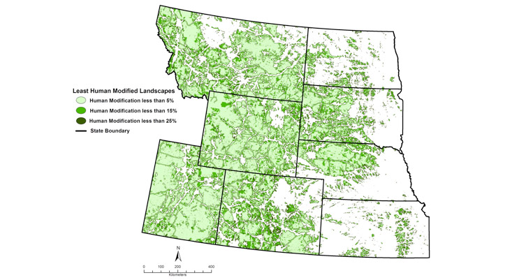
The human modification approach estimates the “magnitude” or degree that a land-use modifies habitat at a specific location and the “footprint” or the proportion of the location containing a specific land use. Our model quantified the extent and ecological influence of major human land-uses known to modify natural landscapes in the Mountain-Prairie Region including: energy development (oil and gas wells, resource extraction mines, wind turbines, power plants, power substations, and transmission lines), extent of human population (housing density), agricultural cropland, roads, railroads, and telecommunication towers.
Our modeling indicated that 54.6% of the Region contained landscapes that were minimally modified (<25>125% higher than their mean population level in landscapes with <25> Our model provides a starting point for conservation agencies to assess structural connectivity of remaining natural land cover within specific ecosystems. However, our results are not indicative of habitat quality for individual species and we suggest that additional species-centered assessments be conducted to determine importance of identified landscapes to individual species.
For more information, contact Chris Swanson.